(949)292-1393

Laguna Niguel

Laguna Niguel is an affluent city located in southern Orange County, California. The name “Laguna Niguel” is derived from the Spanish word “Laguna” which means lagoon, and the word “Nigueli” which was the name of a Juaneño Indian village that was once located on Aliso Creek. The population was 61,891 at the 2000 census. The city was primarily built after 1980 as an unincorporated master planned community located in the San Joaquin Hills near Laguna Beach. Laguna Niguel contains a large range of housing, from condominiums to large mansions above the ocean. It borders Laguna Beach, Dana Point, San Juan Capistrano, Mission Viejo, Laguna Hills, and Aliso Viejo.

History

Laguna Niguel is located on the Rancho Niguel Mexican land grant of Juan Avila. He retained ownership until 1865, when a severe drought killed off most of his cattle. Lewis Moulton, owner of the Moulton Company, bought the area of modern-day Laguna Niguel in 1895, along with significant other portions of the surrounding area from farmers that were hard pressed to earn a living due to a local drought in the area.
In 1959, the Laguna Niguel Corporation, started by Cabot, Cabot & Forbes from Boston, made Laguna Niguel one of the first master planned communities in California. Victor Gruen and Associates, a Vienna architect, developed a community plan for 7,100 acres (29 km2). The Avco Community Developer in 1969 continued the plan, which by then held 6,500 residents. The construction of the San Diego, I-5, Freeway in 1959 allowed more people to arrive. The first communities developed in Laguna Niguel were right along the coast, touching the southern border of Laguna Beach. These communities were called Monarch Bay and the Monarch Bay Terrace built between 1960 and 1962. In 1973, Laguna Niguel Regional Park opened, and in 1974 a one-million square-foot ziggurat building was given to the United States government. On December 1, 1989, Laguna Niguel became an incorporated city in Orange County and became its 29th city

Geography

Laguna Niguel is located at 33°31′55″N 117°42′9″W / 33.53194°N 117.7025°W / 33.53194; -117.7025 (33.531938, -117.702503). According to the United States Census Bureau, the city has a total area of 14.7 square miles (38.1 km²). 14.7 square miles (38.0 km²) of it is land and 0.1 square miles (0.2 km²) of it (0.41%) is water. Laguna Niguel occupies a hilly basin near the southern end of the San Joaquin Hills, a small coastal mountain range in southern Orange County. On the west is 650-foot (200 m) Niguel Hill, which separates the city from Aliso Canyon, an immense gorge cut by Aliso Creek, one of the county’s primary watercourses. The Aliso Canyon area is home to Aliso and Wood Canyons Regional Park, a large wilderness area in the southern county. Although the creek itself only brushes the northwestern border of the city, a major tributary, Sulphur Creek, drains most of northern Laguna Niguel. Sulphur Creek runs through Crown Valley in eastern Laguna Niguel, Crown Valley Park, Laguna Niguel Regional Park and Sulphur Creek Reservoir (Laguna Niguel Lake). The two parks and the lake lie just north of the geographic center of the city.

Sulphur Creek Reservoir

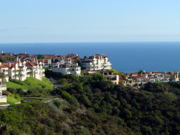
Low ridges dissect much of the Laguna Niguel area. Most of these mountain ridges, some of them attaining heights of one or two hundred feet, run northeast to southwest, delineating the hydrography of the area. Laguna Niguel’s other primary drainage, Salt Creek, has two forks in the southern half of the city, flowing southwards to the Pacific Ocean. Laguna Niguel itself has no border on the ocean. The city of Dana Point to the south separates Laguna Niguel and the Pacific. On the east side, Laguna Niguel is separated from San Juan Capistrano by a significant ridge running along Trabuco Creek. To the north lie Aliso Viejo and Laguna Hills.

Crown Valley and Alicia Parkways are the primary thoroughfares in the city. Crown Valley Parkway runs along Sulphur Creek and the northern fork of Salt Creek, bisecting the city northeast to southwest. Alicia Parkway, mostly a north-south road, follows Aliso Creek to where it joins Crown Valley Parkway in close proximity to Crown Valley Park and the city center. California State Route 73 runs north of the city, diverging from Interstate 5 just northeast of Laguna Niguel.

Moulton Parkway/Street of the Golden Lantern runs along the eastern boundary of Laguna Niguel. Pacific Island Drive/Camino del Avión follow parts of the west and south boundaries, respectively. Another major road, Niguel Road, runs roughly parallel and east of Crown Valley Parkway along the Salt Creek canyon. Marina Hills Drive is the largest crossing between Niguel Road and Golden Lantern, and Aliso Creek Road runs east-west through northern Laguna Niguel.